

It is getting colder and the land is starting to change to reflect that. The forest is starting to look more open as the underbrush is dying off and the leaves are thinning out in the canopies. The whisper of a slight breeze was accented with the crunch of the newly fallen leaves with every step I took. There were several calls from unseen sources that mixed in with the gurgling of the stream to complete the peaceful soundscape that surrounded me. I don’t know my bird calls very well yet, but I recorded them and I will get help from someone more knowledgeable than I. I the field had a trampled line of tall shrubs which could have been made by a deer or a human. The river had barges of floating fallen leaves which swirled around in the currents. The river had an interesting section in it where there were dams on opposite river banks which caused this clockwise current in a section in a place that I expected would flow straight.
Time lapse of the odd current:
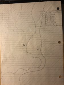
There were several waterbugs in the river and I saw one or two minows darting under the surface. While I was taking the timelapse with my ungloved hands freezing in the cold, I watched as a squirrel darted along the ground. I took out my notebook and started to sketch up a map of my little area of the forest. I do not have much experience with cartography, so it took me quite a long time to get done. The dashed line is the trail, the line with dots is the path of the river, the dotted region is the field, the region willed with dashed lines is the forest. I marked notable points with letters including my center point with an X, a dead standing stump in the field with an S, and a dead V-shaped stump with a V.
Recent Comments