One of our regular features on this blog will be posts on research projects by faculty in our department who agree to share a bit about their current or ongoing work.
Our first entry in this series comes from Associate Professor Nicole Phelps. Professor Phelps received her MA and PhD in History from the University of Minnesota, where she specialized in both American and modern European history. She is the author of U.S.-Habsburg Relations from 1815 to the Paris Peace Conference, which was published by Cambridge University Press in 2013.
“The U.S. Consular Service and a Global American Presence, 1789-1924”
Nicole Phelps
September 29, 2014
When I was researching my dissertation and first book on U.S.-Habsburg relations, I was really struck by the volume, diversity, and importance of the work done by consular officials. The U.S. Consular Service was one of the three main branches of the Department of State prior to 1924, when the U.S. Foreign Service was created; the other two branches were the central office staff, who worked in Washington, and the diplomatic corps, whose members dealt with high politics while posted abroad. In consular records produced by U.S.-Habsburg interaction, I found all sorts of fascinating stuff, from transcripts from trials of naturalized U.S. citizens arrested for political activities in the Habsburg lands and Bertillon records of fugitive diamond smugglers to workers’ compensation cases and pamphlets on conducting business in newly American possessions such as Puerto Rico and the Philippines.
Although the consular records were full of amazing stuff, I discovered that there was very little scholarship on the Consular Service itself, making it a challenge to understand how the consuls serving in the Habsburg Empire fit into the bigger picture of U.S. consular efforts abroad. For my new project, I’ve decided to try and fill that void. Eventually, I’ll end up with a book about what consuls did from the service’s creation in 1789 to its end in 1924, but the first step of the project is determining where the U.S. government operated consular posts and who worked at them. I’m creating a data set drawn from the Register of the Department of State—an annual publication that began in the mid nineteenth century—and the series of cards department officials maintained, which listed who was in charge of each post over time. I’m also creating a series of maps and infographics to show where the posts were located and how those locations shifted over time.
The data set is definitely still a work in progress, but some important results are beginning to emerge. The service is quite a bit larger than one might expect; in looking from 1789 to 1924, I’ve found posts in approximately 1300 different locations so far. The service grew moderately until the outbreak of the Civil War in 1861, at which point it doubled in size and then continued to grow. In 1895, when the service reached its maximum size, nearly 800 posts were operating. (One should keep in mind that consular officials were usually required to find their own office and living space, and many worked for fees, rather than a fixed salary, so there were few logistical pressures operating to check the expansion of the service.) Despite reforms in 1906 and 1924, the number of consular posts declined modestly until World War II, when the nature of Department of State posts abroad altered dramatically. The scope of the Consular Service provides evidence of an important, globe-spanning official U.S. presence in the nineteenth century, despite contemporary rhetoric and subsequent historical scholarship that stressed U.S. isolation from international affairs.
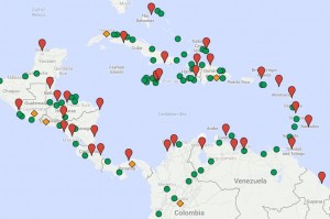
The map shows the U.S. consular presence at its peak in the Caribbean in 1908, shortly after the Roosevelt Corollary introduced a new, more interventionist U.S. policy toward Latin America. The orange diamonds represent consulates general, the highest ranking posts. The red pins are consulates, and the green circles are consular agencies, which were very often operated by non-U.S. citizens. While mapping software has become far more accessible, it still requires modern day place names in order to plot correctly; matching the nineteenth-century names to current cities has been a fun and fairly easily solved puzzle. (And my world geography is becoming better and better!) I still face the challenge of generating base maps that accurately depict nineteenth-century political boundaries, as well as finding effective ways to convey change over time on a single map. I am enjoying the methodological challenges of creating a data set, though I also look forward to the later stages of the project when I will be back in the archives doing text-based research in pursuit of an analytical narrative.

