For some it can be hard to imagine what a landscape looked like 10, 20, 50, or 100 years ago. However, for me, I always find interest in imaging what the landscape previously looked like and how us humans have influenced it over a given time period. Just by walking through Centennial Woods one can easily tell that this is no old growth forest; the trees are much to young and the species found (a lot of maples and white pines) indicate the age of Centennial Woods. Before I get into specifics of what my place in particular used to be (I think), some maps I found in the University of Vermont special collections are very useful to look at:

Centennial Woods Natural Area, 1993
Courtesy of UVM Special Collections
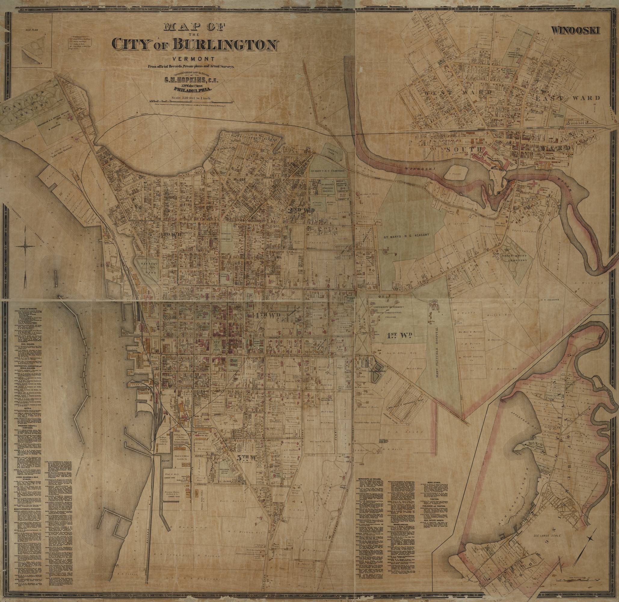
Map of the City of Burlington, Vermont: from official records, private plans, and actual surveys. Courtesy of UVM Special Collections
The first details the purchases of tracts of land for Centennial Woods in 1993, and the second map details the layout of the city of Burlington (home!) in 1890, as well as who owned private tracts of land. According to the 1890 map, parts of Centennial Woods were previously owned by C. Baxter Est., H. Stevens, Hickok Est., and the Ainsworth family. However, I was not able to discover what they used their land for explicitly. I’m going to attempt to infer that using ecology. Given the time period, it would be logical to assume that tracts of land that large are either a wealthy person’s estate or used for agriculture. In fact, according to the Centennial Woods field guide, one can find barbed wire throughout the forest, with trees growing around it. This suggests that the land was formerly a pasture. Also, the presence of white pine (especially around my particular Phenological spot) helps indicate where the forest is in it’s development. White pine is a early successional species that likes coming in after pastures and hay fields have gone to fallow. Using this knowledge, I am assuming that my spot in Centennial Woods used to be mostly agriculture.
I still don’t know what that damn concrete structure is though.
Citations:
Hopkins, G. M. Map of the city of Burlington, Vermont: from official records, private plans and actual surveys. Philadelphia, Pa.: G.M. Hopkins, 1890.
http://cdi.uvm.edu/collections/item/Burlington_Hopkins_1890 (accessed December 02, 2014)
Centennial Woods Natural Area. Burlington, VT: University of Vermont, 1993.
http://www.uvm.edu/~uvmsc/Centennial%20Woods/Centennial_Woods_Survey_1993.jpg (accessed December 02, 2014)
The Changing Landscapes of Centennial Woods Natural Area: A Field Guide [PDF]. University of Vermont Natural Areas. University of Vermont Environmental Program, http://www.uvm.edu/~uvmsc/Centennial%20Woods/Changing_Landscapes_Centennial_Woods002.pdf.