

I would identify Cassavant as a Silver Maple-Ostrich Fern Riverine Floodplain Forest, due especially to it’s proximity to the Winooski River and the abundance of silver maples. Cassavant is along a portion of the Winooski that moves at a moderate gradient, leading me to identify the natural community this was instead of as a Sensitive Fern Floodplain Forest. The soils are slightly sandy which further supports this identification. Other species common to these kind of floodplain forests include boxelder, buckthorn, honeysuckle, and ostrich fern, all of which I have seen in this spot along the Winooski River.
The biggest phenological change that has occurred here at Cassavant is the noticeable lack of snow. Much of the snow has melted off, leaving only small patches here and there. The melting snow has caused the soil to be quite muddy and squishy. It is very different from the icy, hard ground from a couple of weeks ago. The melting snow has also lead to more runoff in the branches of the Winooski river, causing it to be higher than it was prior to the melting. The
I used BioFinder to analyze my phenology spot. I was most interested in how the man-made infrastructure affected the ecosystem at Cassavant. Since the natural area borders a highway, much of the road is designated as high priority animal crossing (shown in red on the map). One of the dangers of having a thriving natural community amid a populated and developed area is dangers of traffic colliding with wildlife. Through denoting the road as a high priority animal crossing, the town hopefully tries to address this issue. Another option could be a wildlife bridge to help animals cross the street. Another thing I was interested in was the uncommon plant and animal species shown on the map in the Cassavant area, which increases the priority of the natural area’s continued protection and conservation, especially considering its close proximity to a developed area.
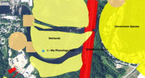
Map of my Phenology Spot Created Using Biofinder