As my site is not situated near any particular location of importance, it was difficult to learn about the history of the exact location I chose. However, my site is located right off of Highway 127 and the Highway 127 bike path (Google, n.d.). Although there is also limited information about the history of the highway, it was built in 1950 as the result of a petition and initially only covered 0.147 miles (“State Highways”, 2007). Since then, it has been expanded once in 1971 by 1.600 miles and then reverted -1.600 miles in 1980 (“State Highways”, 2007). Despite no direct ecological impacts being recorded, it can be assumed that the creation and continuous alteration of both the bike path and the highway caused deforestation and clearing, habitat fragmentation, and a decrease in biodiversity as a result.
Although located on the far west section of the Burlington Intervale, my site is technically included in the extended map of the natural land associated with the Intervale. The Intervale is a floodplain that reaches across 870-acres and has historically provided Burlington with a location for rich biodiversity and sustainable food systems (Berrizbeitia, n.d). Acting as a habitat corridor, many animals have used the Intervale throughout the past as a safe way to traverse the landscape. Similarly, frequent flooding has left the soil extremely fertile and allows for a wide range of plants to grow. The fertility and biodiversity of the site created an ideal location for indigenous Abenaki to live, with the oldest evidence of Native use of the land dating back to 3000 BC (Berrizbeitia, n.d). The remnants of Abenaki life, such as burial sites, ceramics, and various agricultural tools show the history of land use in the Intervale and disclose various seasonal patterns (such as hunting and gathering patterns used by the Abenaki) (Berrizbeitia, n.d). During the late 18th century as European settlers colinized the area, hundreds of acres of the Intervale were cleared and converted into farmlands. It was not until the 1980s that the Intervale began to become converted back to organic farming, largely by Will Raap. Raap went on to found the Intervale Foundation, now known as the Intervale Center, near the end of the 20th century (Berrizbeitia, n.d). The Intervale has been officially recognized by the Intervale Center over the past 20 years as a hub for local food systems, including local farmers, community gardens, and community access to natural spaces.

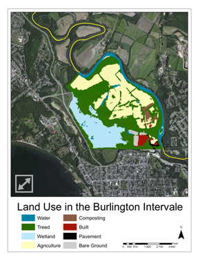
Map of the land use in the Burlington Intervale. My site is located on the far west near the highway, around halfway up the western border. The site technically falls under the treed category, although part of the wetland is noticeable from my site (the marsh).
Works Cited
Berrizbeitia, Ines. “Focal Places in Burlington.” Burlington Geographic, www.uvm.edu/place/burlingtongeographic/focalplaces/int-context.php.
Google. (n.d.). Retrieved from URL
“State Highways History.” Vermont Transportation Maps, Vermont Agency of Transportation, 5 Oct. 2007, vtransmaps.vermont.gov/Maps/Publications/Historical/History_byRoute.pdf.