

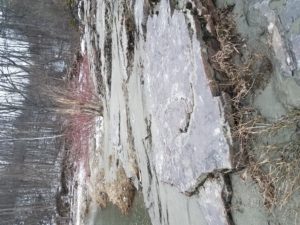
Time to go back to the Salmon Hole! This time I was focusing on the type of community at the Salmon Hole. Using Wetland, Woodland, Wildland to help me decided that the Salmon Hole best fits into to river coble shore category. The reasons for this is because it is a very strong river due to the hydro dam on the river. There is also a lot of rock all over, this is both bedrock and stones of various sizes. The river is very powerful and fluctuates which prevents many types of vegetation growing close to the shore. Where the river has deposited sediment small shrubs have started to grow and this is another example of a river coble shore. As spring continues to come the vegetation will start to grow more and close in on the Salmon hole but then when flooding happens again in the fall and winter these plants will be killed and washed away.
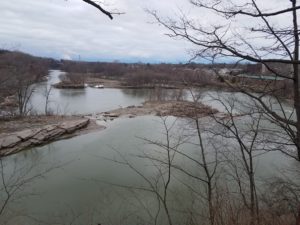
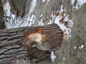
The Salmon Hole has gone under some extreme changes over the past couple weeks. The ice that was once safe enough to walk on back in February is now all gone except a few small pieces. The river is running much higher than it normally does in summer or fall but this is because of all the runoff we have been having with the warm weather melting the snow. The river is running very fast in the main channel as well as a result of the increased water flow. Nothing has started to grow however and the only differences in woody structures such as trees are some new dead trees have appeared thanks to the river depositing them and also a tree was recently cut down by beavers. The higher water has also deposited more substrate on the shore and I wonder if this will result in more shrubs growing closer to the water edge.
While using BioFinder I learned many things. Some of the interesting things I learned were that there is a feeder brook that runs into to river just below the Salmon Hole but also there is apparently one that runs the length of the river. I don’t know if I believe this or not. I also learned that the land next to the river is mostly private. I just assumed it was all town property as it has a trail on it. I was shocked to see that the town of Winooski uses the river as one of its boundaries. This reminded me of how the connecticut river is used to divide Vermont and New Hampshire. Being a fisherman I have spent many hours fishing the Salmon Hole and have fished all the way down to the first railroad bridge below the Salmon Hole. while doing this I have found a few culverts but none of these were listed on the BioFinider. It was also interesting to find out that the area of the river is a high priority because it has rare species. I am assuming this is the sturgeon as there are many signs about them.
Recent Comments