I met Alan Gofberg while we were both helping clean up the West Harford Village General Store on Saturday, September 3. Turns out he was the person who made that incredible video of the Quechee Covered Bridge. Here’s his story in his own words (and photos):
Quechee Covered Bridge 8-28-11 by Alan Gofberg
I am a weather guy (hobby), I knew a hurricane was coming and was excited, but wary at the same time. I was concerned about lengthy power outages (I had been through Gloria in CT). But at the same time the call for possibly 4+ inches of rain made me wonder something I had always guessed. I always assumed that if we got that kind of rain in a short time all bets would be off because of the mountains. I did not expect what transpired to happen however.
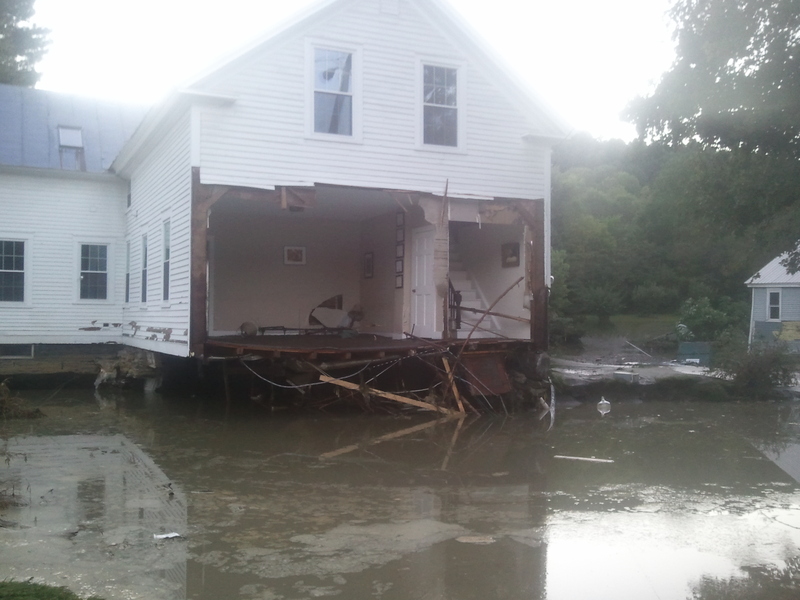
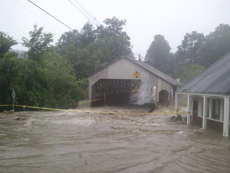
So Sunday morning the 28th we got up and headed out for a late breakfast at Dana’s. I was quite aware that it had rained a phenomenal amount over night and was still at it. There was NO wind at all. We were bemused at a tourist bus and some people going out to see the gorge in that weather. At 11:30 we checked out the covered bridge in Quechee, looking at Simon Pierce. The water was high, but nothing crazy. My daughter went to friends and after a few hours I decided to look again. It was 1:30 and things had changed considerably. I went on the bridge and took some pics, it was much higher than I had ever seen. There was a carnival atmosphere in town, lots of people, cops, fire trucks. I walked up the street and could see the green beginning to flood. There was a river across it that was coming down from Willard Rd. The red barn in Quechee was taking water on the base floor. It was surreal. Amidst all of this I was calling everyone and finding out roads were closed, warning people (including my parents who live in the white house on the opposite side of the river across from the West Hartford store). I was soaked to the core, trying to use my phone to take pics, and talk to people while not ruining it.
Walking back towards the bridge I noticed Simon Pierce was taking lots of water. I walked up and snapped a few pics. It was hard to believe the water could get much higher. Then I looked at the Quechee bridge, and it was roped off, and a chill went up my spine. The water was maybe 4-5 feet below it. I took off for home worried about getting there since I figured out road would flood. It had begun to but was still passable. I passed this information on to people and spoke with my parents warning them to WATCH the White River. They played it cool and said it was not that bad yet. The White was 3-4 hours behind the Ottauquechee. After an hour or so I had to know, was the bridge really threatened, it is over 45 feet above the water. It seemed impossible. I climbed up to the road above me to go back out, our road was under 4 feet of water. Not many people out anymore. There were 2 teenagers though at the new spot they roped the road off, maybe 100 yards from the bridge, you could not get close(conventionally). I could see it was taking water though. We climbed up to the road above it, traversed across, and dropped down through some trees and were looking at the bridge straight on. It was surreal, the road had so much water on it and had become a river. The bridge was getting pounded, ripped apart in places. I shot many pictures despite being soaked to the core, and then decided to shoot a video. I was there for maybe 30 minutes and then ran home, immediately uploading my video to Youtube and putting it on Facebook. Everyone started linking it out like crazy. The next day it would be on the New York Times, Weather Channel and Cnn. Good Morning America asked me if they could use it the next morning. http://www.youtube.com/watch?v=DsdfsY2BBiw . I had shot so many pictures but at the last second shot a video, and did not realize how much more powerful it could be.
I informed everyone of how bad it had gotten. My parents in White River were scared, the White River was reaching the bridge, they fled and tried to get to my sister’s place in Quechee (which is uphill). There was some doubt if they could make it though, their place is off Willard which was a river. I noticed my video was getting lots of comments which surprised me since I had put ski videos up before and no-one ever said anything. In one comment someone asked if the bridge still stood, and someone responded saying it was gone. I had to see, I went out one more time. This time it was a carnival atmosphere again, people had gotten word, they had all seen my video. I took a few more pics, and shot one more video. The Bridge still stood but the roadway in front of it had completely caved in. My daughter had come down with the family she was visiting at from the other side of town, she could not come home though because the roads were closed. I spoke with my sister who was worried about my parents, at this point phones were faltering, too many people using their phones, overwhelming the towers. My friend took my up to my sisters place to check on them. The road had huge rocks on it everywhere and one side had caved in completely, it was precarious. We got their and they were safe. I took off for home.
The next morning I woke up at 5 and had to know if my parents house made it. I knew a fancy back way to West Hartford and made it there. The river was still shockingly high, just below the bridge. There house was ok, but one of few. I walked across the bridge and could not believe the destruction. I headed over the mountain to pass on the news, and stopped to look at the Quechee bridge to see how it ended up. The road dropped 20 feet in front of the bridge, but the bridge still stood, barely. What was even more amazing was the erosion though. A bank of trees that kids climbed down to swim under the bridge was completely gone and now you could see the river from the road, something that you could not do before. I told my parents the good news and took a hot shower at my sisters place, since my place had no water(it went under the bridge). That was one of the most whirlwind 18 hours or so I have ever had. The most amazing part about it was the height of the river, but as the speed at which it rose. in 3 hours it went from a little high, to higher than I have seen in 15 years (ultimately cresting higher than ever recorded).
That was my experience.